Showing 38 items matching whittlesea subdivision
-
 Whittlesea Historical Society Inc.
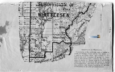
Booklet - Electoral Roll, Commonwealth of Australia. State of Victoria. Division of Corio. Roll of Electors for the Subdivision of Whittlesea, 1914
... Corio. Roll of Electors for the Subdivision of Whittlesea... and occupation of Electors for Subdivision of Whittlesea. Dated 1914... for the Subdivision of Whittlesea Paper, typed document, staples along spine ...Paper, typed document, staples along spine, some loose pages, very fragile, 19 p., map.Alphabetical list of names including residence and occupation of Electors for Subdivision of Whittlesea. Dated 1914. By Authority: Albert J. Mullet Government Printer for the State of Victoria.whittlesea, roll of electors, yan yean, morang, doreen, arthurs creek, linton -
 Whittlesea Historical Society Inc.
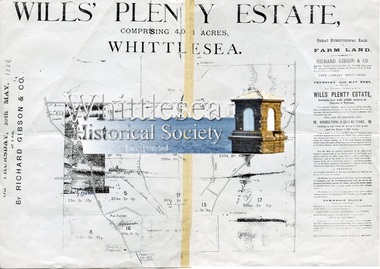
Document - Copy, Flyer, Will's Plenty Estate, Whittlesea, 1888
... whittlesea subdivision..., Whittlesea 1 sheet, photocopy, a plan of subdivision showing the sale ...The Will's Plenty Estate containing about 4,056 acres, surrounding the Township of Whittlesea, was originally purchased by Thomas Wills in 1839, and divided into tenant farms. The sale of the Wills Estate was one of the earliest functions conducted in the Whittlesea Mechanics Institiute on Thursday 20th May, 1886. Thomas Wills (1800-1872) was a J.P., and a son of Edward Spencer Wills an influential Sydney merchant. In 1840 he purchased 176 acres of land at the junction of Darebin Creek and the Yarra River, in what is now Alphington, and there he built a two-storey house named 'Lucerne', the grandest home of its day. In later years he built another large home just across the river from Lucerne which he called Willsmere. He was a good friend of Governor La Trobe who is said to have been a frequent visitor.1 sheet, photocopy, a plan of subdivision showing the sale by auction of allotments with map showing location of tenants and layout. The document has torn along the middle fold line and has sticky tap on it.Richard Gibson & Co.wills estate, whittlesea, tenant farm, thomas wills, map of whittlesea, whittlesea mechanics institute, map, whittlesea subdivision -
 Whittlesea Historical Society Inc.
Archive - Box, WHS Originals - Documents, Photo Album, Lockwood Diaries
... . Booklet - Roll of Electors for the Subdivision of Whittlesea.... Booklet - Roll of Electors for the Subdivision of Whittlesea, 1914 ...Archive Box - WHS Originals - Documents, Photo Album, Lockwood Diaries. Contents: 1. Envelope. Material relating to William Henry Lockwood, Engineer, Shire of Whittlesea. Contents: 1. Book - Diary, 1853, William Henry Lockwood 2. Book - Work Book, c.1854, William Henry Lockwood. 3. Certificate - Right of Burial, Yan Yean Cemetery, 1893, William Henry and Joseph Lockwood 4. Document - Contract No.16, Shire of Whittlesea, Running Creek Road 5. Document - Contract No.7, Shire of Whittlesea, Plenty Main Road 6. Document - Contract, Shire of Whittlesea, Sanitary Service, Township of Whittlesea 7. Letter - 1894, J. Sabelberg, Solicitor, to Mr. Lockwood, Shire Engineer, Whittlesea 8. Photocopy of Letter - 1894, J. Sabelberg, Solicitor, to Mr. Lockwood, Shire Engineer, Whittlesea 9. Transcription, handwritten Letter - 1894, J. Sabelberg, Solicitor, to Mr. Lockwood, Shire Engineer, Whittlesea 10. Photograph. Lockwood family group. 11. Document - Specifications for the erection of a dwelling house for the Church of England Clergyman at Whittlesea. 12. Document - Family history, William Henry Lockwood (possibly belongs with Item No.16 Letter, Australian Mutual Publications Pty., Ltd., to Sister Mary Lockwood, Whittlesea). 13. Envelope - Lockwood papers a. 1892, Yan Yean Cemetery receipt, Jas H. Lockwood. b. 1895, Yan Yean Cemetery receipt, W H. Lockwood. c. 1888, Elector's Right, James Henry Lockwood. 14. Envelope - R. M. Cuthbertson a. 1906, receipt, Millpark Farm, South Morang. 15. Folder - "A Copy of the Diary of William Lockwood 1853". Contents: Typed copy 1853 Diary of William Henry Lockwood (26 pages), brief history of the ship Marco Polo, Preface, Acknowledgments, letters (2) from National Maritime Museum. 16. Plastic sleeve pocket - Contents: 1. Document, 1878, Certificate of Service, W. H. Lockwood. 2. Letter, Australian Mutual Publications Pty., Ltd., to Sister Mary Lockwood, Whittlesea (possibly belongs with Item No.12 Document - Family history, William Henry Lockwood). 17. Photocopies - 1. 1853 Lockwood Diary. 2. Indenture, 1763, Joseph Lockwood (2 pages). 3. Letter, 1879, W. H. Lockwood to The Minister of Public Instruction. 4. Letter, 1887, W. H. Lockwood to Education Department. 5. Document, 1878, Certificate of Service, W. H. Lockwood. 6. Document, 1888, Elector's Right, James Henry Lockwood. 7. Article: Ship That Shrank The World, Reader's Digest August 1988, also letters (2) from National Maritime Museum. 18. Letter, 1871, Coolart Station to Sally (Read Family Letters, Patrick Reid Jnr.) 2. Album - The School Papers, 1943, Alison Graff, Mernda 488, Form VIII. 3. Booklet - Rules and Regulations of the Whittlesea Free Library, with Catalogue of Books, 1887. 4. Envelope - Plastic zip lock bag containing Photographs and Memorial Cards. (handwritten note attached note states 8 all together, however the bag contains 10) 1. Photograph - Annie McCarthy, Blacksmiths daughter, Wollert. 2. Photograph - Man standing holding a rifle, probably a Wuchatsch from S. Gippsland. 3. Photograph - Karl Wuchatsch and family of Nyora, Vic., c.1892. 4. Memorial Card - Jeremiah D. Hearn, 1895. 5. Memorial Card - Walter Edward Hehr, 1904. 6. Memorial Card - Jacob Hehr, 1903. 7. Memorial Card - Johann Christian Ludwig Seeber, 1904. 8. Memorial Card - Ernest Adolph Wuchatsch, 1889. 9. Memorial Card - Traugott, husband of C. Wiedemann, 1903. 10. Memorial Card - Charles Hallett Ingall, 1902. 5. Plastic zip lock bag. Contains material relating to Eden Park Cricket Club. 1. Exercise Book - Eden Park Cricket Club Minute Book, 1946-1947. 2. Receipt Book - Eden Park Cricket Club Cash Receipt Book, 1954. 3. Original Newspaper article, Kinglake Cricket Team, The Sun, May 2, 1987. 4. Photographs - 7 B&W photos, Eden Park area. 6. Booklet - Whittlesea Lodge, No. 256, Installation of Bro. Albert Harold Wailes, 1971. 7. Transcription - Handwritten transcript of newspaper article, State School Whittlesea Distribution of Prizes, The Evelyn Observer, January 4, 1884. 8. Plastic pocket - containing original Map, Pint Pot Estate, Whittlesea, 1888. 9. A4 sheet protector (labelled Back to W/Sea 1937) - contains a list of names handwritten on a sheet of paper, top line reads "Former Head Master Thos Jobling with some of his former scholars". Probably belongs with the corresponding photograph (photograph missing) 10. A4 sheet protector - contains, Document, receipt from John McKimmie, 1901. 11. A4 sheet protector - contains, Document, Entry Form, Shire of Whittlesea Exhibition, 1975. 12. A4 sheet protector - contains, Colour Photograph of a black and white photograph of The Australian Cricket Team, May 1884, also hand written notes on a sheet of paper. 13. A4 sheet protector - contains, Document, Transfer of Land, James Morris of Whittlesea, 1897. 14. A4 sheet protector - contains, Document, Whittlesea Town Common, 1868, original documents (2) 15. Booklet - Roll of Electors for the Subdivision of Whittlesea, 1914. 16. A4 sheet protector - contains, Photocopies, newspaper articles, Yan Yean Cemetery history, 4 pages.Grey coloured Archive Box with documentsWHS Originals - Documents, Photo Album, Lockwood Diaries -
 Eltham District Historical Society Inc
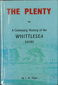
Book, J. W. Payne, The Plenty: A Centenary History of the Whittlesea Shire, 1975
This book traces the one hundered years of the development of the Shire of Whittlesea, from the discovery by Hume and Hovell in 1824 to the time of the centenary in 1975. The intervening years saw the settlement of Vandemonians, Sydney-siders, English, Scots, Irish and Germans, Black Thursday, the building of the Yan Yean Reservoir, the Plenty River flour millls, the timber industry, fruit-growing and export and vineyards. Personalities and pubs, subdivisions, stories of the Findon Hunt Club and various Shires including Epping. History of education and transiton from rural to urban in the south of the Shire. The work is illustrated with maps and photographs. The Shire is now the City of Whittlesea and is an immediate neighbour to the north of the Shire of Nillumbik. shire of whittlesea -
 Whittlesea Historical Society Inc.
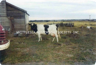
Photograph - Copy, Pindari Estate, McDonalds Road, Epping, c.1950s - 1970s
This colour photograph, along with 4 others, was taken of the Pindari Estate before subdivision c.1950s - 1970s. The estate was formerly known as "Nev's Hideaway" the property of Neville Eynon.Historical property of the City of Whittlesea.Colour photograph printed on paper, photo 1 of 5.pindari estate, mill park, nev's hideaway, neville eynon, eynon family, cow, paddock -
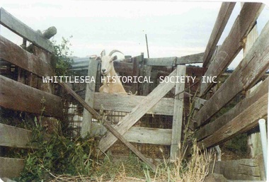 Whittlesea Historical Society Inc.
Photograph - Copy, Pindari Estate, McDonalds Road, Epping, c.1950s - 1970s
This colour photograph, along with 4 others, was taken of the Pindari Estate before subdivision c.1950s - 1970s. The estate was formerly known as "Nev's Hideaway" the property of Neville Eynon.Historical property of the City of Whittlesea.Colour photograph printed on paper, photo 2 of 5.Annotation reverse: Pindari Estate pet goatpindari estate, mill park, nev's hideaway, neville eynon, eynon family, paddock, pet goat -
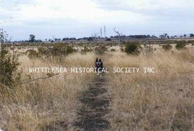 Whittlesea Historical Society Inc.
Photograph - Copy, Pindari Estate, McDonalds Road, Epping, c.1950s - 1970s
This colour photograph, along with 4 others, was taken of the Pindari Estate before subdivision c.1950s - 1970s. The estate was formerly known as "Nev's Hideaway" the property of Neville Eynon.Historical property of the City of Whittlesea.Colour photograph printed on paper, photo 3 of 5.Annotation reverse: Pindari Estate before subdivision/ looking south toward Mill Park.pindari estate, mill park, nev's hideaway, neville eynon, eynon family, paddock -
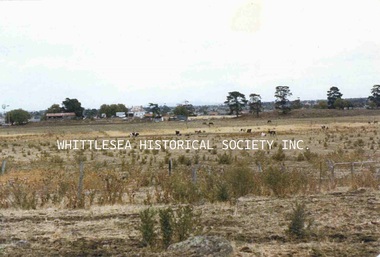 Whittlesea Historical Society Inc.
Photograph - Copy, Pindari Estate, McDonalds Road, Epping, c.1950s - 1970s
This colour photograph, along with 4 others, was taken of the Pindari Estate before subdivision c.1950s - 1970s. The estate was formerly known as "Nev's Hideaway" the property of Neville Eynon.Historical property of the City of Whittlesea.Colour photograph printed on paper, photo 4 of 5.Annotation reverse: Pindari Estate looking east to Soliminallos homesteadpindari estate, mill park, nev's hideaway, neville eynon, eynon family, paddock -
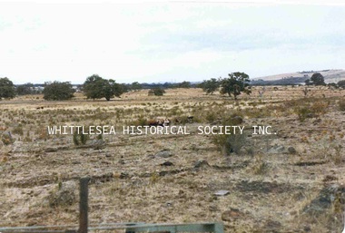 Whittlesea Historical Society Inc.
Photograph - Copy, Pindari Estate, McDonalds Road, Epping, c.1950s - 1970s
This colour photograph, along with 4 others, was taken of the Pindari Estate before subdivision c.1950s - 1970s. The estate was formerly known as "Nev's Hideaway" the property of Neville Eynon.Historical property of the City of Whittlesea.Colour photograph printed on paper, photo 5 of 5.Annotation reverse: looking toward South Morang.pindari estate, mill park, nev's hideaway, neville eynon, eynon family, paddock, south morang -
Whittlesea Historical Society Inc.
Archive - Box, Whittlesea Historical Society - WHS - Maps. 1
Archive Box with lid - Whittlesea Historical Society - WHS - Maps. 1. Contents: 1. Green binder Folder, labelled "Maps", with inventory of contents. Contents: 1. Map Parish of Keelbundora, 11 June 1956, large sheet 2. Map Parish of Keelbundora, undated, one sheet 3. Map Parish of Keelbundora, 1946 4. Map Parish of Keelbundora 5. Map Parish of Keelbundora, 5 Jun 1953 6. Map Parish of Keelbundora, blue sheet 7. Morang - Portions 11-14, A4 page 8. Golden Wattle Estate, 23 Feb 1962, A3 sheet 9. Range View Estate, A4 sheet 10. Golden Wattle Ranges Estate, 22 Feb 1962, A4 sheet 11. Golden Wattle Estate Hurstbridge, A3 12. Shire of Whittlesea including Epping Station, Nov 86, A3 13. Whittlesea, including Epping Road, A3 14. Station Estate Thomastown including Thomastown Railway Station 15. Station Estate Thomastown including Thomastown Railway Station 16. Thomastown Estate, date prior to decimal currency, A3 poster 17. Certificate of Title - Thomastown Station subdivision, 18 Oct 1926, Transfer of Lands Act Titles 18. Plan of Subdivison of Stages 1 & 2 Thomastown 19. Poster - Auction Sale Thomastown, 27 Oct 1923 20. Thomastown, 24 Nov 1907. Grey coloured Archive Box containing mapsWhittlesea Historical Society - WHS - Maps. Box 1.map, archive, achival box -
 Whittlesea Historical Society Inc.
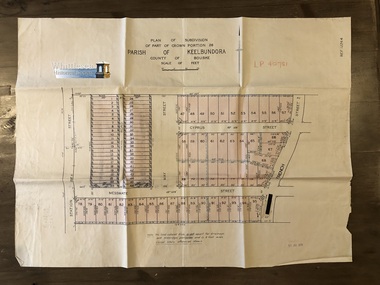
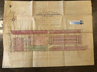
Map, Garlick and Stewart, Engineers and Surveyors, Plan of Subdivision of Part of Crown Portion 26, Parish of Keelbundora, County of Bourke, c. 1956
Subdivision of Part of Crown Portion 26, Lalor, Vic. Station Street, Messmate Street, May Street, Cyprus Street and French Street recorded on the map.Map shows subdivision of blocks numbered 1 - 95, sizes of the blocks, and names of the surrounding streets. Map 1 of 20 in green folder.Garlick and Stewart, Engineers and Surveyors, Melbourne. LP 40751. Sealed 11 Jul 1956map, subdivision map, station street, messmate street, may street, cyprus street, french street, lalor -
 Whittlesea Historical Society Inc.
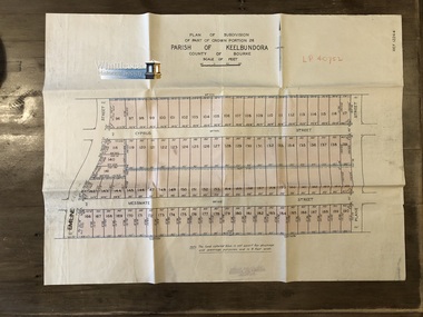
Map, Garlick and Stewart, Engineers and Surveyors, Plan of Subdivision of Part of Crown Portion 26, Parish of Keelbundora, County of Bourke, c. 1956
Subdivision of Part of Crown Portion 26, Lalor, Vic. French Street, Messmate Street, Cyprus Street and Plane Street recorded on the map.Map shows subdivision of blocks numbered 96 - 190, sizes of the blocks, and names of the surrounding streets. Map 2 of 20 in green folder.Garlick and Stewart, Engineers and Surveyors, Melbourne. LP 40752. Not dated, assumed 11 Jul 1956.map, subdivision map, messmate street, cyprus street, french street, lalor, plane street, lalor map -
 Whittlesea Historical Society Inc.
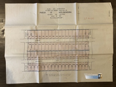
Map, Garlick and Stewart, Engineers and Surveyors, Plan of Subdivision of Part of Crown Portion 26, Parish of Keelbundora, County of Bourke, c. 1956
Subdivision of Part of Crown Portion 26, Lalor, Vic. Messmate Street, Cyprus Street, Ash Street and Plane Street recorded on the map.Map shows subdivision of blocks numbered 191 - 262, sizes of the blocks, and names of the surrounding streets. Map 3 of 20 in green folder.Garlick and Stewart, Engineers and Surveyors, Melbourne. LP 40753. Not dated, assumed 11 Jul 1956.map, subdivision map, messmate street, cyprus street, lalor, plane street, lalor map, ash street -
 Whittlesea Historical Society Inc.
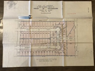
Map, Garlick and Stewart, Engineers and Surveyors, Plan of Subdivision of Part of Crown Portion 26, Parish of Keelbundora, County of Bourke, c. 1956
Subdivision of Part of Crown Portion 26, Lalor, Vic. Messmate Street, Cyprus Street, Ash Street, Maple Street and Daltons Road recorded on the map.Map shows subdivision of blocks numbered 263 - 329, sizes of the blocks, and names of the surrounding streets. Map 4 of 20 in green folder.Garlick and Stewart, Engineers and Surveyors, Melbourne. LP 40754. Not dated, assumed 11 Jul 1956.map, subdivision map, messmate street, cyprus street, lalor, plane street, lalor map, ash street -
 Whittlesea Historical Society Inc.
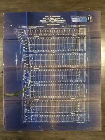
Map, Gulliver & Sim, Licensed Surveyors, Plan of Subdivision of Part of Crown Portion 26, Parish of Keelbundora, County of Bourke, c. 1953
Subdivision of Part of Crown Portion 26, Lalor, Vic. Map 1: Station St, David St, William St, May St, French St and Dalton Road. Map 2: David St, William St, Munro St, Jean St, Lorne St, Plane St, Ash St and Dalton Road. Messmate Street, Cyprus Street, Ash Street, Maple Street and Daltons Road recorded on the map.Two sheets, attached. The maps are fragile and have tears along the fold lines. Map 1. shows subdivision of blocks numbered 19 - 124, sizes of the blocks, and names of the surrounding streets. Map 2. shows subdivision of blocks numbered 19 - 124, sizes of the blocks, and names of the surrounding streets. Map 5 of 20 in green folder. Map 1. LP 29211. Map 2. LP 29212. Both maps, Sealed 13 May 1953. Gulliver & Sim, Licensed Surveyors, 15 Lorrean Avenue, East Brighton. S6. Tel. X54780.map, subdivision map, lalor, plane street, lalor map, ash street, david street, william street, may street, french street, dalton road -
 Whittlesea Historical Society Inc.
Map, Plan of Subdivision of Part of Crown Section 25, at Thomastown, Parish of Keelbundora, County of Bourke
Plan of Subdivision of Part of Crown Section 25, at Thomastown, Parish of Keelbundora, County of Bourke Epping Road, Mount View Road, Tramoo St, Hurtle St, Arndell St, Travers St, Westall St, Chappell St, and Pleasant Road, recorded on the map.Blue sheet. Aged sticky tape on map. Map 6 of 20 in green folder. Shows subdivision of blocks numbered 1 - 340, sizes of the blocks, and names of the surrounding streets. LP 13050. Undated.map, subdivision map, thomastown map, thomastown, epping road, mount view road, tramoo street, hurtle street, arndell street, travers street, westall street, chappell street, pleasant road -
 Whittlesea Historical Society Inc.
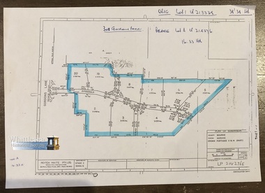
Map, Peyton Waite Pty. Ltd, Consulting Land Surveyors, Plan of Subdivision, County Bourke, Parish Morang, Crown Portions 11 & 14 (Part)
Morang is now as Mernda. Plan of Subdivision, County Bourke, Parish Morang, Crown Portions 11 & 14 (Part). Gordons Lane and Fitzgerald Court, recorded on the map.A4 page. Map 7 of 20 in green folder. Shows subdivision of Crown Portions 11 &14 (part) blocks numbered 2 - 8 and 19 - 20, sizes of the blocks, and names of the surrounding streets.LP 214276E Undated. Peyton Waite Pty. Ltd, Consulting Land Surveyors, 353 Plenty Road, Preston. Vic.map, subdivision map, morang, mernda, gordons road, fitzgerald court, morang map, mernda map, plan of subdivision -
 Whittlesea Historical Society Inc.
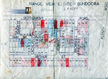
Map, Range View Estate - Bundoora
Range View Estate - Bundoora, Settlement Road near Plenty Road, including Elms St, May St, May Court, Lachlan St, Edward St, Brownhill St and Arthur St.Undated, A4 sheet. Map 9 of 20 in green folder. Shows block number and names of the surrounding streets names, one section bounded by Settlement Road.L.P 25185map, subdivision map, range view estate, bundoora, settlement road bundoora, plenty road bundoora, may st, lachlan st, brownhill st, arthur st, elms st -
 Whittlesea Historical Society Inc.
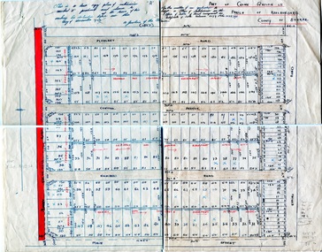
Map, Thomastown Subdivision, Part of Crown Portion 25, 1926
... Whittlesea melbourne Map Thomastown Subdivision, Part of Crown ...1 sheet. Map 17 of 20 in green folder. Dated December 1926, shows sizes of the blocks, names of the surrounding streets, Mount View Road, Epping Road, Main Street, Pleasant Road, Central Avenue, Highlands Road."A" Part of Crown Portion 25, Parish of Keelbundora, County of Bourke. Certificate of Title Volume 5179 Folio 1035791.map, thomastown, crown portion 25, parish of keelbundora, subdivision, 1926 -
 Whittlesea Historical Society Inc.
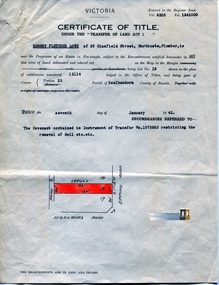
Document - Certificate of Title, Certificate of Title, Vol. 6205 Fol. 1241000, 7 Jan 1942
Title in the name of Hornby Fletcher Lowe of 29 Glanfield Street, Northcote, Plumber, Lot 18 on Plan of subdivision 12114, part of Crown portion 25, Parish of Keelbundora County of Bourke, dated 7th January 1942.1 p. coloursubdivision, northcote, hornby fletcher lowe, highlands road thomastown -
 Whittlesea Historical Society Inc.
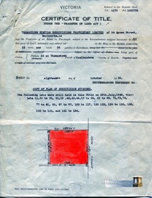
Document - Certificate of Title, Certificate of Title, Vol. 5179 Fol. 1035791, 18 Oct 1926
Title in the name of Thomastown Station Subdivisions Propriety Limited of 94 Queen Street, Melbourne, 32 acres being part of Portion 25 at Thomastown, Parish of Keelbundora County of Bourke, dated 18th October 1926.1 p. coloursubdivision, thomastown, thomastown station subdivisions, epping road, main street thomastown, portion 25 thomastown -
 Whittlesea Historical Society Inc.
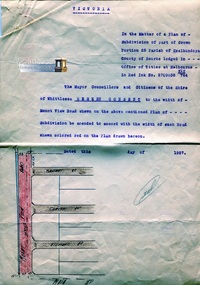
Document, Mount View Road, 1927
Subdivision of part of Crown Portion 25 Parish of Keelbundora County of Bourke, consent to the width of Mount View Road.1 p. coloursubdivision, thomastown, thomastown station subdivisions, epping road, main street thomastown, portion 25 thomastown, mount view road thomastown -
 Whittlesea Historical Society Inc.
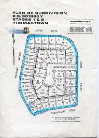
Map - Plan of Subdivision, Stages 1 & 2 Thomastown
... Whittlesea melbourne Plan of Subdivision Map Stages 1 & 2 Thomastown ...Linton Drive, Milgrove Avenue, Queenscliff Road, Grovedale Close, Thomastown1 sheet, coloured, copy, undated. Map 18 of 20 in green folder. Beveridge Williams & Co., P.L.map, thomastown -
 Whittlesea Historical Society Inc.
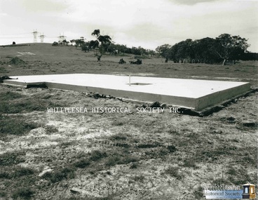
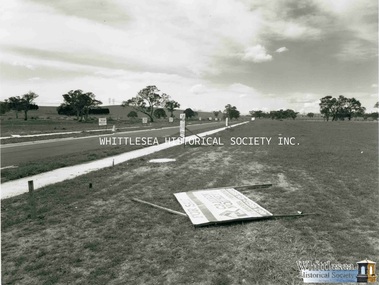
Photograph, Evan Meades, Meadow Glen Estate, Aug 1988
One of a series of photographs taken in 1988-1989 around the Shire of Whittlesea by Evan Meades.Print copy of a photograph"Meadow Glen Estate 35 Horseshoe Cres. Epping Aug 88"evan meades collection, meadow glen estate, epping, meadow glen estate epping, 35 horseshoe drive epping, concrete house slab, subdivision -
 Whittlesea Historical Society Inc.
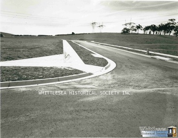
Photograph, Evan Meades, Meadow Glen Estate, Sep 1988
One of a series of photographs taken in 1988-1989 around the Shire of Whittlesea by Evan Meades.Print copy of a photograph"Crn. Bromley Place and Longwood Drive. Meadow Glen Estate Epping Sept 88"evan meades collection, meadow glen estate, epping, meadow glen estate epping, subdivision, bromley place epping, longwood drive epping -
 Whittlesea Historical Society Inc.
Photograph, Evan Meades, Meadow Glen Estate, Oct 1988
One of a series of photographs taken in 1988-1989 around the Shire of Whittlesea by Evan Meades.Print copy of a photograph" Cavesson Court Meadow Glen Estate Epping Oct 88"evan meades collection, meadow glen estate, epping, meadow glen estate epping, subdivision, cavesson court epping -
 Whittlesea Historical Society Inc.
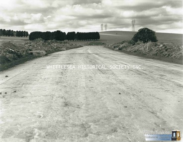
Photograph, Evan Meades, Meadow Glen Estate, Sep 1988
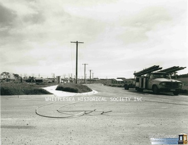
One of a series of photographs taken in 1988-1989 around the Shire of Whittlesea by Evan Meades.Print copy of a photograph"Meadow Glen Estate Cnr Meadow Glen Drv. + Horseshoe Cres. (Nth) looking west. Epping Sept 88"evan meades collection, meadow glen estate, epping, meadow glen estate epping, subdivision, meadow glen drive epping, horseshoe cresent epping -
 Whittlesea Historical Society Inc.
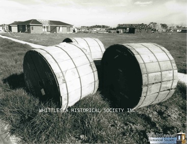
Photograph, Evan Meades, Meadow Glen Estate, cable drums, Aug 1988
One of a series of photographs taken in 1988-1989 around the Shire of Whittlesea by Evan Meades.Print copy of a photograph"Meadow Glen Estate Cnr Meadow Glen Drv. + Horseshoe Cres. (Nth) looking west. Epping Aug 88"evan meades collection, meadow glen estate, epping, meadow glen estate epping, subdivision, meadow glen drive epping, horseshoe cresent epping, cable drums -
 Whittlesea Historical Society Inc.
Photograph, Evan Meades, Meadow Glen Estate, Guinea Court, Aug 1988
One of a series of photographs taken in 1988-1989 around the Shire of Whittlesea by Evan Meades.Print copy of a photograph"Meadow Glen Estate Guinea Crt, looking east. Epping Aug 88"evan meades collection, meadow glen estate, epping, meadow glen estate epping, subdivision, guinea court epping -
 Whittlesea Historical Society Inc.
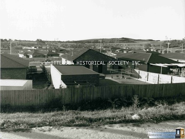
Photograph, Evan Meades, Meadow Glen Estate, Sep 1988
One of a series of photographs taken in 1988-1989 around the Shire of Whittlesea by Evan Meades.Print copy of a photograph"Meadow Glen Estate from McDonald's Rd looking Nth Epping Sept 88"evan meades collection, meadow glen estate, epping, meadow glen estate epping, subdivision, mcdonalds road epping